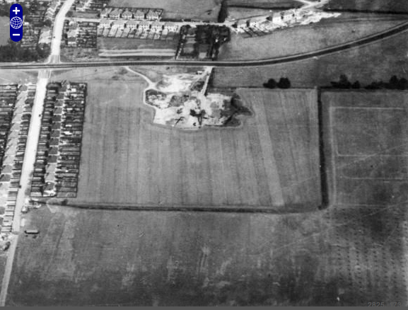
I’ve realised that the aerial view of Moulsham in 1935 that I reproduced in a recent post is probably the best photographic image that we have of the site of Moulsham Hall, before the area was built over. As such, perhaps it can offer clues that will help us in our quest to establish the Hall’s exact location.

‘The residential area of Moulsham and environs, Chelmsford,1935’ via britainfromabove.org.uk
The photograph was taken from the south, with Longstomps Avenue and the site of Moulsham Schools in the foreground, and Moulsham Street and part of the town in the background. In the middle is the area that we now know as ‘old Moulsham’, which at the time was only just beginning to be developed. Some of Moulsham Drive has been built, and the first houses of Oaklands Crescent and St John’s Avenue are tentatively edging out from Vicarage Road and St John’s Road respectively.
But between them is an open space, albeit one that has the route to be taken by new roads already mapped out. They look rather like the criss-cross lines on a hot cross bun against the dark background of the ancient fields they will soon cover forever.

‘Old’ Moulsham in the 1935 aerial photograph
In my earlier post, I remarked on the clear image that this photograph gives us of Moulsham Hall Gardens, the dark rectangle between Moulsham Drive and Princes Road, and a little to the east of Vicarage Road. Last week I cited evidence that these walled gardens were identical with the kitchen garden constructed by Benjamin Mildmay, Earl Fitzwalter, as part of his rebuilding of Moulsham Hall in the first half of the eighteenth century. We know that the kitchen garden stood at a short distance from the Hall, probably to the south-west of it. That would place the actual mansion somewhere in the middle of that open area that I just highlighted on the aerial photograph.
Despite the encroachment of the new roads, we can still make out the ancient field patterns in this area. For example, we can see a straight line, indicating a field boundary, emanating from the northerly end of Moulsham Hall Gardens, then bending to the right before meeting the junction of what will soon be Oaklands Crescent and St John’s Avenue. Beyond this, there is a break before a dark blob and the line continues on its way towards the backs of the houses of St John’s Avenue. Here it is met by another field boundary emanating from the vicinity of Vicarage Road.

‘Old Moulsham’ in the 1888-1913 Ordnance Survey map, overlaid on a modern map of the area (via maps.nls.uk)
If we turn to the Ordnance Survey Six Inch map of the area, dated 1888 – 1913, overlaid on a contemporary map, as found on the website of the National Library of Scotland, we can see the original field boundaries more clearly (see above). We can see that the field boundary that ran north-eastwards from Moulsham Hall Gardens made a jagged turn at the junction of the future Oaklands Crescent and St John’s Avenue, as reflected in the aerial photograph. What could account for this? Could it be that the line was following the boundary of the site of the Hall, or even of the Hall itself?
Even more intriguing are the two small ‘blobs’ to be seen further along, to the south of the field boundary and coinciding with St John’s Avenue. Unfortunately, these don’t quite correlate with the dark blob that we identified on the 1935 aerial photograph: they seem to have already disappeared, or been built over, by then. If we focus more closely on the Ordnance Survey image (see below), we can see that these two blobs are coloured blue: in other words, they are expanses of water.

‘Close-up’ of part of the 1888-1913 Ordnance Survey map of Moulsham
Now, in David Hughson’s 1809 publication, London; Being an Accurate History and Description of the British Metropolis and its Neighbourhood, we read an intriguing description of the manor of Moulsham:
On the manor of Moulsham stands what remains of the mansion house of this great and antient family, distinguished by the name of Moulsham Hall. It is delightfully placed on an easy ascent about a quarter of a mile on the east side of the town of Chelmsford. The grand front commands Danbury Hill. […] The situation of Moulsham Hall commands a beautiful view of pasturage and meadow land, where the Chelmer and Cann unite their streams. The gardens were neatly laid out; the park prettily disposed, and on the north side a large sheet of water [my italics].
Is it possible that the two ponds on the Ordnance Survey map are all that remained of this ‘large sheet of water’? If so, and this lake was ‘on north side’ of the 18th century Hall, then that would place the house in the area between Moulsham Drive and St John’s Avenue – in other words, within the boundaries of the field with the jagged western edge.

Another ‘close-up’ of the 1888-1913 Ordnance Survey map of Moulsham
On the other hand, the ‘easy ascent’ described by Houghton might be represented by the 100 yard contour line on the Ordnance Survey map, which would place the site of the Hall slightly further to the north and closer to the footpath that would eventually become St John’s Road (but then, of course, there’s a triangle marking a ‘rise’ of 122 feet a little the south of this: roughly where Fortinbras Way stands today). This might make sense, since I believe that St John’s Road follows the route taken by the original approach to Moulsham Hall in Tudor times, as shown in Walker’s map of 1591:

Part of John Walker’s ‘trew platt of the mannor and hamlett of Moulshum’ dated 1591 (Reproduced by courtesy of the Essex Record Office, Ref. D/DM P2).
Houghton’s description also provides a striking reminder that the inhabitants of Moulsham Hall had an uninterrupted view across open countryside, not only towards the meeting of the Rivers Chelmer and Can at Moulsham Mill, but all the way to Danbury – something that is almost impossible for us to imagine today.