
In my last post I shared some of the photographs of Moulsham Hall Gardens that were kindly sent to me by Sue Stacy. These photographs, taken by wildlife photographer C W Teager, who lived in a house within the walled gardens, improve our understanding of the precise location of Moulsham Hall – and provide a fascinating glimpse of the Moulsham area before the developers moved in.
In this post I’m sharing some more of Teager’s photographs. To begin with, here are two more photos of Moulsham Hall Gardens when he was living there. The first shows the house in the gardens, and the second seems to have been taken from the house itself, with the houses of Moulsham Drive beyond. Both show the gardens in bloom, presumably in spring time, and perhaps in the 1950s.


The next photograph is labelled by Teager ‘The town from M.H.G. Moulsham Drive now occupies the immediate foreground’. As Sue comments, this suggests that the gardens were not walled on all sides – unless of course the photograph was taken looking over the wall and these chicken coops were actually outside the gardens. Either way, this is an intriguing picture of the old Moulsham area before its was built on, meaning that it must have been taken as long ago as the 1920s or early 1930s.

The photograph below is a reminder that, even after old Moulsham began to be developed in the 1930s, it was still semi-rural, with fields lying just beyond the new streets. The caption on this picture reads ‘Standing on Moulsham Drive midway between “MH Garden” & Vicarage Rd, looking toward houses on west side of Vicarage Rd’:

And this photograph is labelled ‘A corner of the meadow: now Oaklands Cresc’:
The next photograph seems to date from the time before the area was developed. The caption reads: ‘Oaklands Park in background. Hedge in foreground site of Moulsham Drive at juncture with Vicarage Rd’:

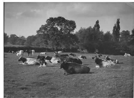
Finally (for now), here are two photographs taken by Teager of the farmland beyond Old Moulsham – I believe these show the area that would in time become Moulsham Lodge Estate. The first bears the caption ‘Mr Paine with his four-horse team (Mr Currie’s farm) 1923’:

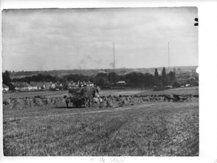
The final photograph in this post, showing men at work in the fields, with houses in the background, is labelled ‘Middle Stomps’. On Walker’s Moulsham map of 1591, one of the fields close to Moulsham Hall is labelled ‘Lower Stomps’, and of course Longstomps Avenue runs along the western edge of what was once the manor of Moulsham. But where exactly was the field called Middle Stomps – does anyone know? I think the view is towards the town (the cathedral is just visible near the horizon), in which case the clump of trees in the middle distance could be Oaklands. As always, I’d love to hear from anyone with information that might throw light on these questions.

If you are in contact with Sue Stacy, I would be grateful if you would ask her if I could get copies of the MHG photos, and possibly some others
LikeLike
Apologies for only just approving your comments, Robin. I haven’t been active on this site for a couple of years now. I’ll work through your message and try to address the points you raise. You can contact Sue Stacy at: suestacy@robstacy.info
Best wishes, Martin.
LikeLike
I should have ticked the boxes below, which is where she can contact me.
LikeLike